The 14km out and back hike to Meg Hut in the Pisa Conservation Area starts close to Cardrona off the Crown Range Road.
It’s a great hike that’s easily accessible from the popular Queenstown and Wanaka yet is off the beaten path…and is the gateway to several other longer hikes in the Pisa Conservation Area.
In the first 22 days of July (granted it’s the middle of winter), there were only five entries in the Intentions Book.
TABLE OF CONTENTS
1. Details about the Meg Hut Pack Track
2. Map of the Meg Hut hike
3. How to get to the Trailhead
4. My experience hiking to Meg Hut
5. Tips for stay at Meg Hut
1. DETAILS ABOUT THE MEG HUT PACK TRACK
When1: I’ve been up a few times, most recently in July 2021.
Difficulty2: Medium. It’s a good slog up the hill, but isn’t technical as you follow a 4WD/farm road all the way.
Hike Distance3: The distance from Tuohys Gully Road car park to Meg Hut is 7km each way based on the DOC signs, and is consistent with my Strava data.
That’s a 14km return trip, provided you don’t walk any other sections of the track.
Incline4: The incline to Meg Hut totals about 723 metres on the way to Meg Hut. On the way backs there’s a smidgin over 200 metres of elevation gain.
Here’s the elevation chart starting from Cardrona Valley Road:
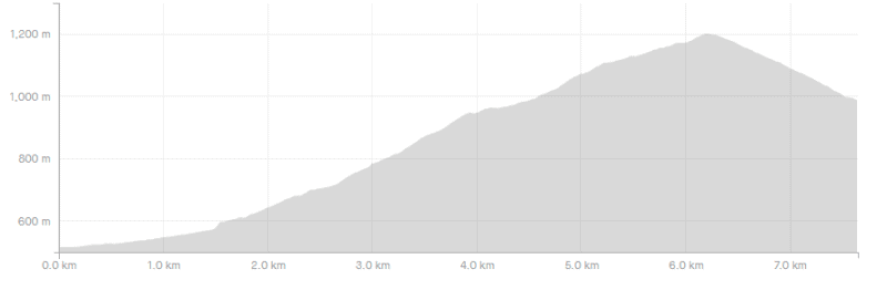
Hike Duration5: It took me right on 2 hours to walk from Cardrona Valley Road to Meg Hut and 1 hour 35 minutes to return. If you’re walking from the car park, it’d be a little less.
That said I’m reasonably fit, and it may take you 2.5 to 3 hours to hike to Meg Hut.
2. MAP OF THE MEG HUT HIKE
The map above shows the GPX file from my Strava recording for the walk from Cardrona Valley Road to Meg Hut on a topo map.
3. HOW TO GET TO THE TRAILHEAD
The hike to Meg Hut starts at the Tuohys Gully Road car park here.
I’m assuming you’ve made your way to Cardrona (you can easily hitchhike from Queenstown and Wanaka) and from there it’s a couple of kilometres south before turning right onto Tuohy’s Gully Road (it’s just before the turnoff to Cardrona Alpine Resort).
It’s not a nice walk with minimal space on the side of the road, so if you can, drive to the car park.
Once on Tuohy’s Gully Road follow the road around to the right (you don’t want to go up the Snow Farm route). After a few hundred metres you’ll see a green and yellow sign mentioning the car park is 200 metres away.
You’ll need to open two fences to get there, don’t forget to close them 🙂
p.s. Skiing at Snow Farm is amazing! I love it.
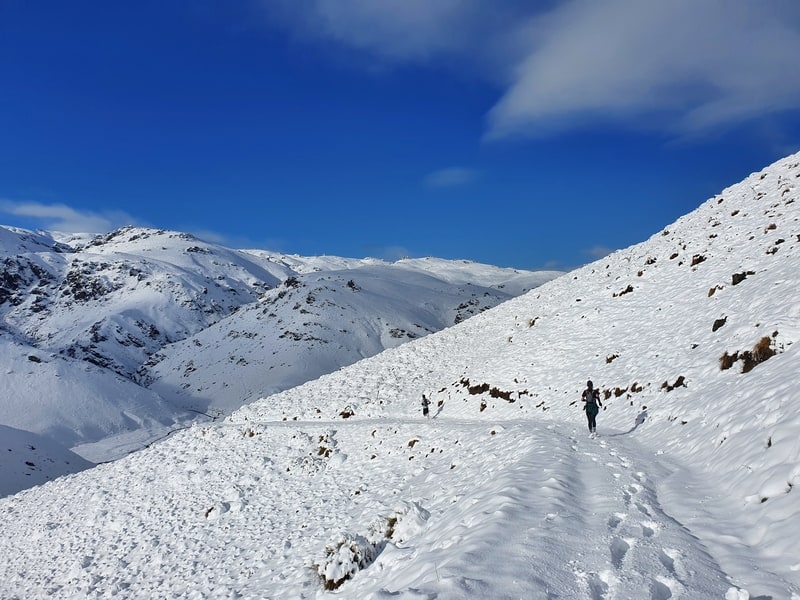
4. MY EXPERIENCE HIKING TO MEG HUT
The start of the track is right next to the car park with orange markers leading the way. At the time I last did this hike there’s the opportunity to bring some firewood to the hut right by the entrance.
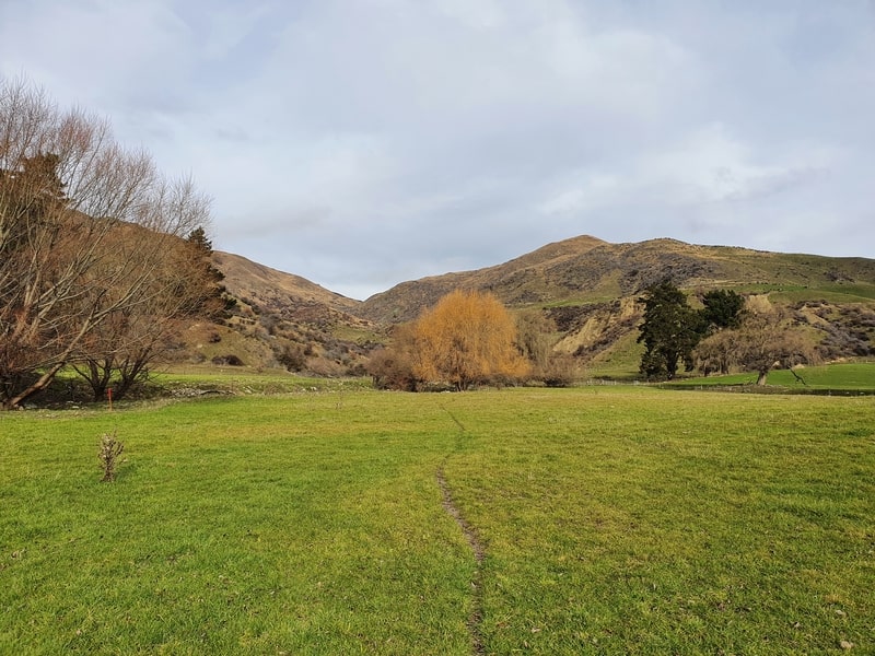
The walk starts off following what’s best described as single trail through farmland close to a stream.
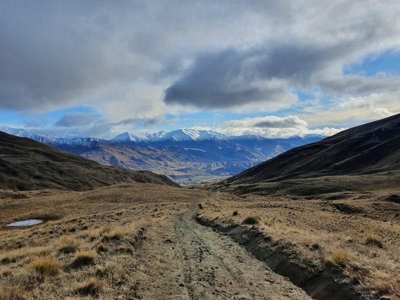
It’s not until you get a few hundred metres along when the trail switches onto a 4WD track which you’ll be following the rest of the way.
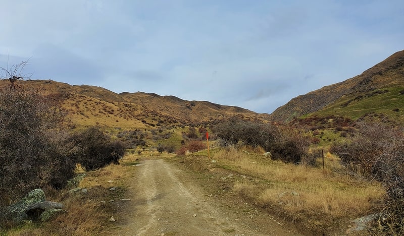
As you continue hiking up the track it does feel like it’s constantly going up. There are a few little flatter sections, not that I really noticed them haha.
The scenery on the way up isn’t 10/10 amazing, but it’s knowing you’ll see very few people on the trail which is awesome.
Be prepared for a continuos climb, which if it has been raining recently is going to have some slippery slopes. There’s a couple of streams to hop over, but unless there’s heaps of rain you can avoid getting your feet wet.
If you’re on struggle street, take a moment to pause and look back towards the way you came. The views aren’t too shabby towards the ski fields.
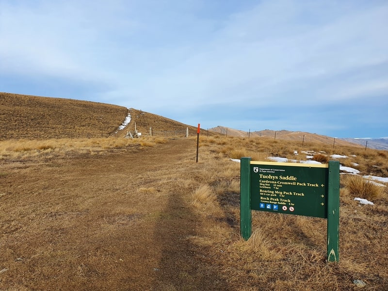
The climb continues on for about 5.5km, when you’ll get to Tuohy’s Saddle. From here, you’ll want to go left (there’s a green and yellow DOC sign for directions – if you turn right, that’s the Rock Peak Track) and finish off the final little climb before the descent down into the valley to the hut.
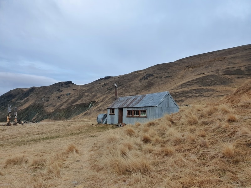
You’ll see Meg Hut come into view on your way down.
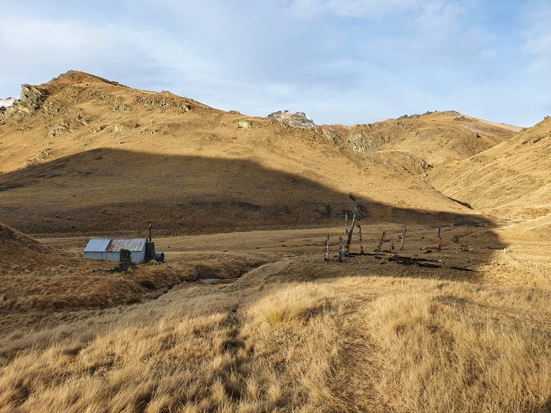
The descent is abuot 1.5km long and like the uphill, is pretty steep before flattening out for the final 100 metres or so. There’s one little stream to hop over right before the hut, but then you’ve made it.
If you’re doing this as an overnight hike from Queenstown or Wanaka, take a moment to appreciate where you are. It’s pretty cool looking at all the surrounding peaks. Heading back?
When you’re ready, it’s time to work for a bit before heading back to the car park. The descent isn’t too bad on the knees 🙂
There’s also the option to continue hiking beyond Meg Hut towards Deep Creek Hut and Cromwell via the Cardrona-Cromwell Pack Track, or even the Roaring Meg Pack Track.
5. TIPS FOR STAYING IN MEG HUT
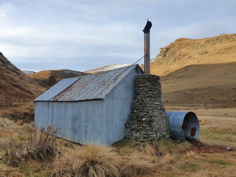
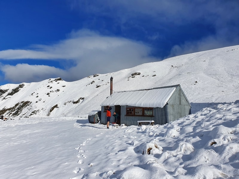
Meg Hut is not as fancy as the huts you’ll find on the Great Walks. But I loved it here. Even staying for two nights in the middle of winter it wasn’t that cold (there wasn’t snow at the hut level at the time).
As long as you have a DOC Backcountry Hut Pass or have purchased a standard hut ticket ($5), there’s no need to book Meg Hut in advance.
And based on the Intentions Book, there’s a good chance you’ll have the hut to yourself, even in summer. As I mentioned earlier, through the first 22 days of July, there were just five nights that’d been booked out in advance.
Here are some quick thoughts about staying in Meg Hut:
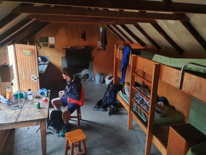
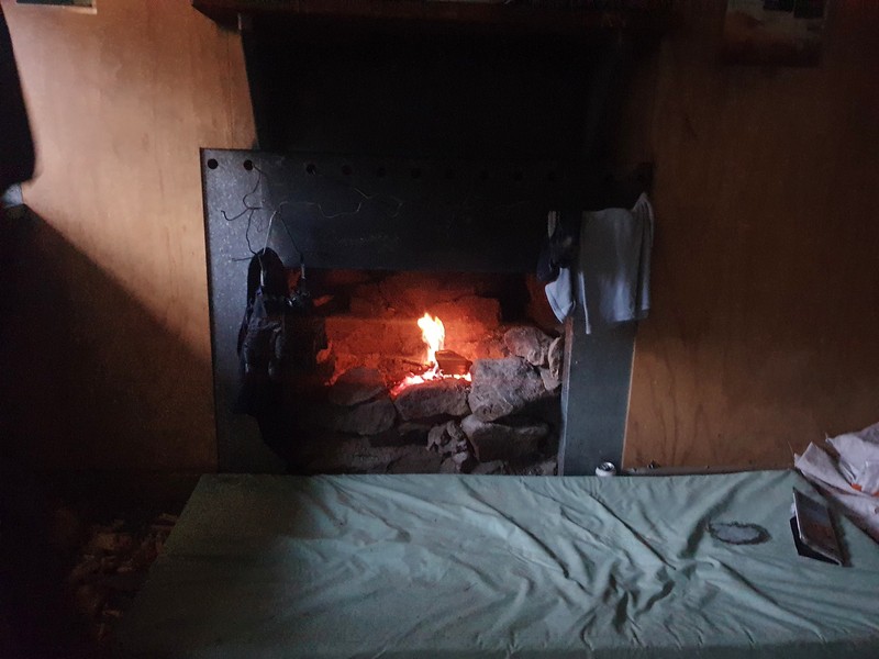
- There are eight bunk beds (with mattresses) in Meg Hut, a couple of wooden chairs, a table, and a fireplace. A pretty standard backcountry hut in New Zealand.
- During the winter the hut only gets a little bit of sun in the morning before the sun drifts back behind a hill. So it’s not a naturally warm hut.
- There’s a toilet you can use. If possible, bring a full roll of toilet paper and leave what you don’t use for other guests who forget.
- There’s a cross-section of streams right by the hut. I’m not exactly sure if I would drink out of them confidently as there is some farm stock in the area, but I did drink out of them personally and had no issues.
- There’s no phone reception in the hut. You can find it as you climb out of the valley in most directions…walk 10 minutes back toward Tuohy’s Saddle and you should get back into some signal.
- A good alternative to staying at Meg Hut in Pisa Conservation Area is Kirtle Burn Hut.
- If you’re planning to use the fire, bring as much of your own firewood as possible. At the time of writing (July 2021), there was some you could get next to the car park.
- I was able to get there in the snow (which started about halfway) comfortably. The 4WD track was easy to follow. But of course, do this at your own risk and bring the appropriate gear.
- Buy your supplies in Queenstown or Wanaka before you head up to the start of the hike. There’s a general store in Cardrona, but there’s not a bg selection of things, and what there is, is super expensive.
- Afterwards, head to the Cardrona Hotel for a beer and a feed.
The hike into Meg Hut is an awesome off-the-beaten-path hike close to Cardrona, and if you’re not in a rush to get between Queenstown to Wanaka is a great way to spend some time.
While you can make the hike in and out in one day, if you can, stay overnight. it’s a great introduction to multi-day hikes on the South Island.
If you have any questions or whatnot, send me an email jub@churnewzealand.com or drop a comment below.
RECOMMENDED READING
Hiking the Little Criffel Track
A hike that also takes you into the Pisa Conservation Range.
Hiking up Mount Horn near Cromwell
Another great hike nearby.
Wanaka’s Skyline Track
Walking along Wanaka’s great skyline.

Hey, it’s Jub here. I’m the guy behind Chur New Zealand, helping you have the best time hiking, trekking, walking…whatever you want to call it…in NZ. I’m based in Queenstown and am always out and about exploring trails, old & new. If you have any questions, reach out.
Just FYI, the GPS map of your trip into Meg Hut is actually one for Little Criffel.
Hey Alex, thanks for the headsup on that. Fixed that now 🙂 Cheers. Jub!
Will you need to book in advance if we are a party of 6? Can’t see where to book.
Hey Tyler,
You can’t book Meg Hut, it’s a first in first serve hut. With 6, I’d make sure to bring tents just in case.
Cheers,
Jub