If you’re looking for a hike that Kiwis love, the Wharekirauponga Track in Coromandel Forest Park ticks most of our boxes. There’s:
- plenty beautiful bush to walk through
- it’s not well known among tourists
- there’s a cool waterfall at the end.
Even the Whangamata visitor centre staff weren’t able to tell me much about the hike and suggested the more popular Wentworth Valley waterfall walk instead. But this post has got you covered with everything you need to know about exploring the Wharekirauponga Loop Track.
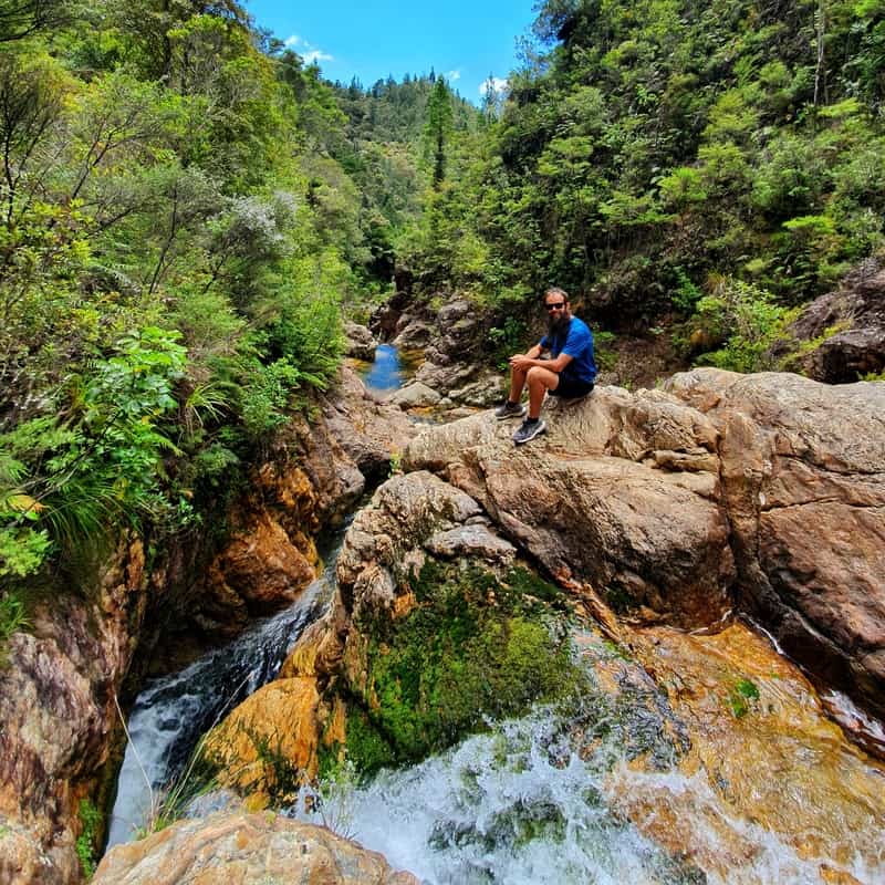
TABLE OF CONTENTS
1. Wharekirauponga Track Details & FAQ
2. Wharekirauponga Track Map
3. How To Get There
4. My Wharekirauponga Trip Report
1. WHAREKIRAUPONGA TRACK DETAILS & FAQ
- QUICK DETAILS:
- 12km return
- 150 to 200 metres elevation
- 2.5 to 3.5 hours
- Easy
- Download the GPX File here
Considering I’d never heard of this track before getting to Whangamata, and couldn’t find much information about it online, I enjoyed this much more than expected. Hikes like these make NZ an awesome hiking destination.
Sure, the first two-thirds of the walk is a bit of a drag with minimal elevation and the scenery not changing much through the Parakiwai Valley. But it gets fun for the last kilometre with inclines and trickier sections to navigate. And the waterfalls are cool, and who doesn’t love visiting off-the-beaten-path places?
How long is the Wharekirauponga Track?
~11km according to my Strava recording. It’ll be slightly open when the full track is open (partly closed due to Kauri Dieback disease). Interestingly, the DOC website says it’s 10km return.
How hard is the Wharekirau Track?
Easy. It’s a gentle rise for the most part, with just a bit more of a technical section near the waterfall. But it’ll be fine.
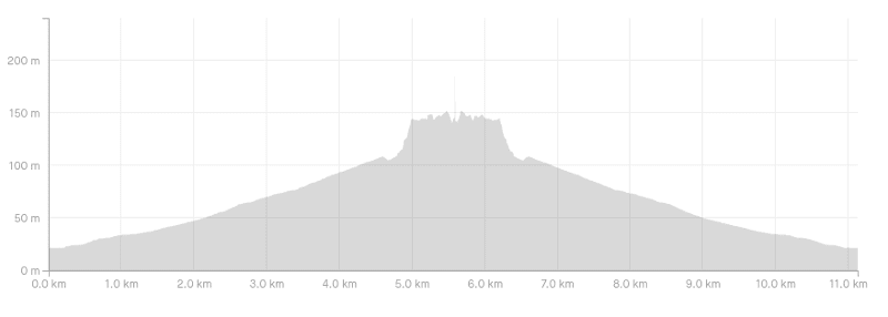
What is the Wharekirau Ponga elevation profile?
158 metres based on my data. If the full loop is open, this might increase to 200 metres.
Here’s the elevation profile:
How long does it take to walk the Wharekirauponga Track?
It took me 2 hours and 28 minutes to return back to the start of the trailhead. I’d say about 2 hours and 15 minutes of this was walking time there and back, with 13 minutes at the waterfall.
The DOC signs say that walking time is 3 hours 30 minutes, so for most people, if you allocated 2.5-3.5 hours you’ll be good (that includes time at the waterfall)
Are dogs allowed on the track?
No.
2. WHAREKIRAUPONGA WALKING TRACK MAP
*Clicking the map below will open it up in a new window.
This map is my GPX file overlaid on an NZ Topomap. I recommend this topo map app if you’re going to be hiking a lot around NZ.
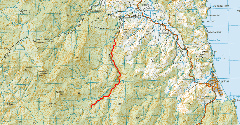
On Google Maps the trail isn’t marked, but the trailhead is pinned here.
On Maps.me you’ll see the track with the loop at the end marked as you can see below (if you search ‘Wharekirauponga Loop’ it’ll come up). There’s no reception most of the time so it was nice to have this as a backup.
3. HOW TO GET THERE
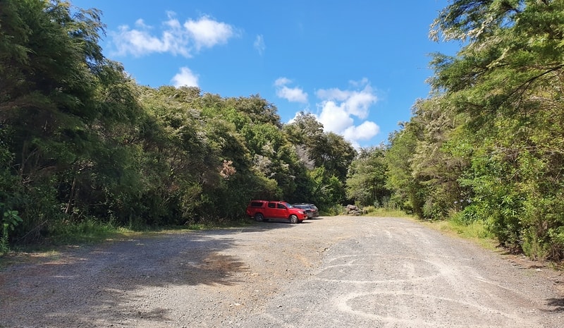
The carpark next to the Wharekirauponga trailhead.
Public Transport: No option.
Walk: Not practical as the trailhead is ~9km from Whangamata and no footpath along a section of the highway with blind corners.
Driving: It takes less than 15 minutes to drive from the centre of Whangamata to the trailhead. Exiting Whangamata, you drive south on State Highway 25 for a few kilometres before turning right onto Parakiwai Quarry Road.
This road has a few houses but is super quiet and the second half is gravel. You keep following the road for 2.5km until you reach the trailhead where there’s a massive carpark. Make sure to keep your valuables on you/out of sight/at your accommodation. The trailhead is literally next to the carpark, you can’t miss it 🙂
4. WHAREKIRAUPONGA TRACK TRIP REPORT
Arriving at the trailhead I was straight under the tree canopy which was great as it was a warm day. There was a small Kauri dieback prevention station so make sure to clean your shoes with the equipment provided if it’s still there when you go.
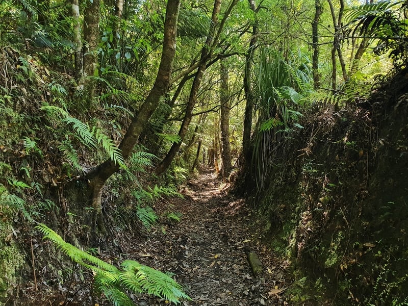
The walk is super relaxed to start with, and well it is for the first 4.6km as you walk the easy-to-follow track on the most gentle of inclines. There were a few muddy sections that were easily navigated, but I can imagine in winter you might get muddy shoes.
Nothing out of control, just something to keep in mind.
There was also a section where a tree with lots of vines had fallen on the track I had to climb through…I’d imagine that would have been cleared by the time you read this (let me know).
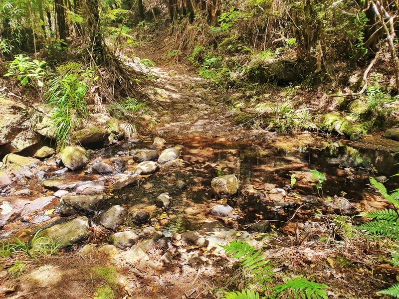
There’s a little creek you need to hop over on the way too.
Along the way, you’re following the river most of the time, and if you want there are definitely a couple of good swimming holes (there’s a good one just after the first bridge crossing), but you might as well skip them as you’ll get a good chance to swim at the top of the Wharekirauponga loop where the waterfall is.
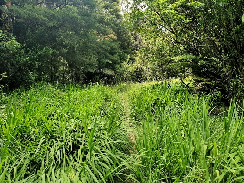
This grassy section is a distinct change in terrain and is where the loop splits off usually. Assuming the loop is still partially closed, turn right here.
🙁
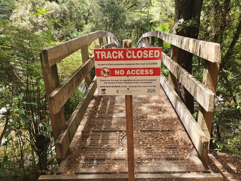
It’s when I got to this section above, the loop starts that the track starts to get fun. The turnoff heading left is overgrown now as that’s the direction the track is closed. If you go left you to get about one minute along where you’ll meet the bridge and you’ll see the signs up letting you know it’s closed. So turn right!
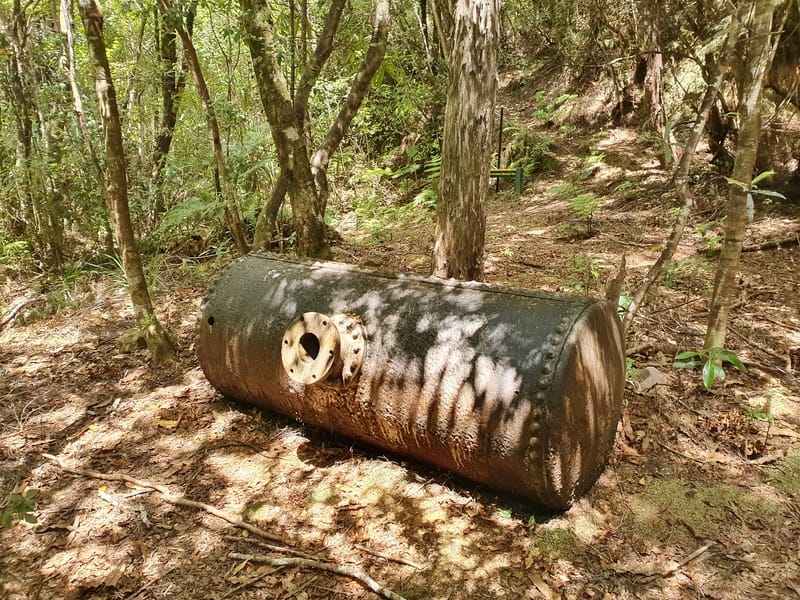
This might have something to do with the Royal Standard Battery Site? But what is it?
Shortly after, you’ll see a sign saying Royal Standard Battery Site. I wasn’t really sure what this meant but follow the track up around the back of the sign? You’ve got a short steep section to navigate here which is where it’s more interesting, nothing crazy but fun.
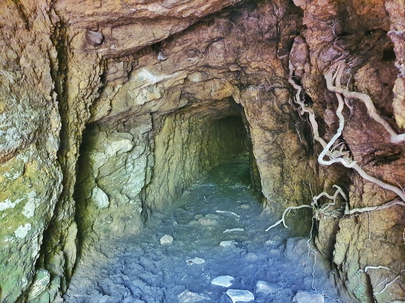
You’ve gotta walk through this, how cool!
You’ll come across the awesome tunnel! How cool, right? It’s no more than 30 metres long but I did feel like I should put my phone light on as it could get well and truly muddy.
Why a tunnel? The Wharekirauponga Track is an old horse-drawn tram track that would lead to the Royal Standard Goldmine back in the day.
After this, you’ve got one rocky section where a rope is there to hold onto if you really need it.
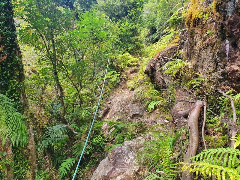
This is the trickiest section of the hike. It’s short, so nothing too crazy.
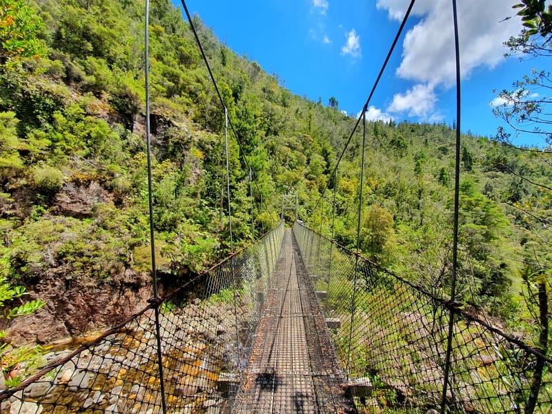
It’s not a bad looking suspension bridge, right?
And then before you know it you’ll come across the suspension bridge that gives you a view of the Wharekirauponga Falls.
I found the water really dark, nearly black, and I still have no idea what that is from? It’s not unsafe to swim in etc. but I’d love to know if there’s a scientific reason behind the colour.
To get down to the section you can swim at the bottom of the falls, cross the bridge and turn left after you get off the bridge and carefully navigate your way down. The falls are perfect for swimming, and there’s a ledge that’s perfect for cliff jumping as the water level is usually high enough (always check depth when cliff jumping). It’s not a massive jump, but it would be cool. I’m not actually sure how to get to the jumping spot, but people have definitely jumped off there before (I’m no cliff jumping feign).
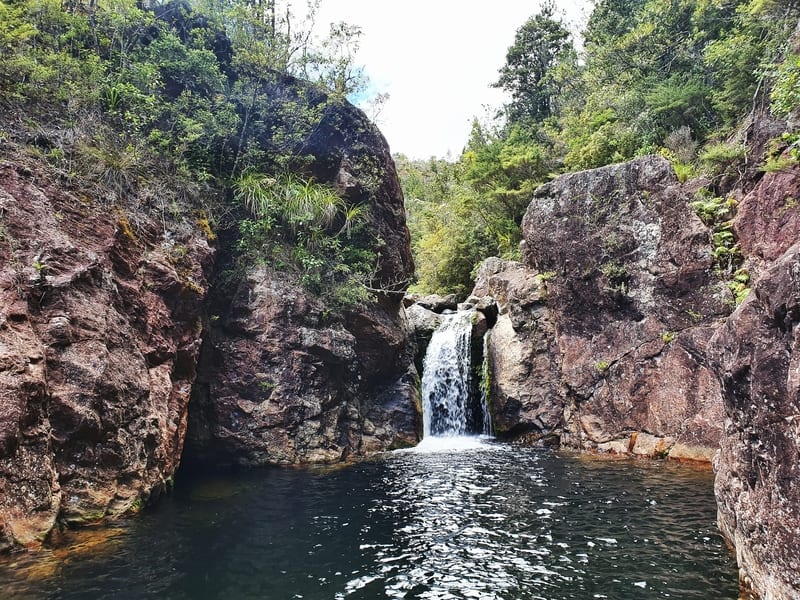
The falls! You can see the cliff jumping spot on the right hand side.
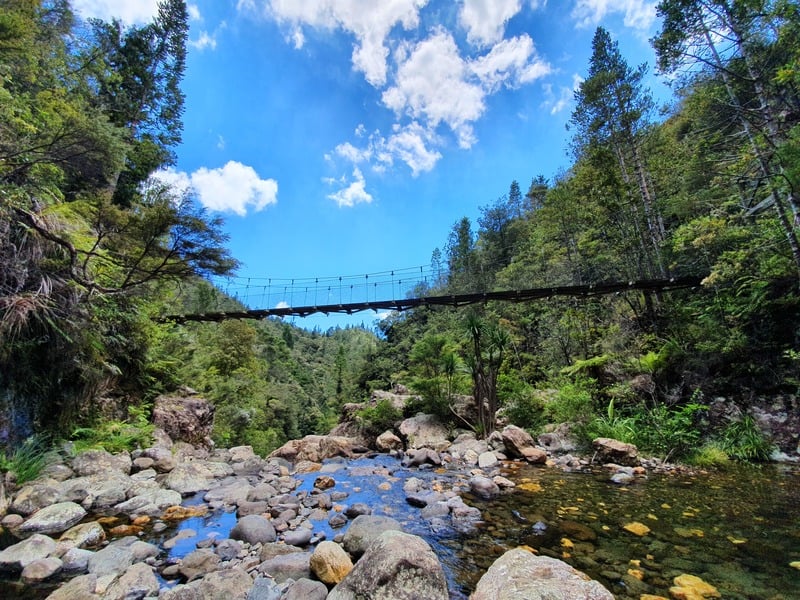
Another nice view looking up towards the suspension bridge.
The photo you saw at the top of the post is from the same area as the falls, but it’s from the top of the next waterfall that you can’t really see because of the rock formations, but I loved that view!
Anyhow, after you’ve spent time at the falls and down all you want to it’s time to head back the way you came. That is unless the full loop has been reopened again (the other point where the track is closed is just beyond the bridge by the falls).
The walk back is fun to start with, given the elevation and the tunnel. But again, that last section which is pretty much flat is a bit annoying after a while (#firstworldproblems).
Considering there was so little info on this hike online (including Instagram) I was stoked it wasn’t a fail and can imagine this spot getting more popular in the coming years.
If you’ve got any questions/comments about the Wharekirauponga Track, feel free to leave a message below or email jub@churnewzealand.com.
What to read next:
- Is the famous Cathedral Cove walk worth it?
- Visit the mural town, Katikati
- Heaps of fun things to do in New Zealand
- 5 Walks in Coromandel Town

Hey, it’s Jub here. I’m the guy behind Chur New Zealand, helping you have the best time hiking, trekking, walking…whatever you want to call it…in NZ. I’m based in Queenstown and am always out and about exploring trails, old & new. If you have any questions, reach out.
Black water often from brewed organic material from forest.
Helicopters probably due to gold mine exploration in area (WKP).
awesome, thanks for the intel J!
Love this track! Crazy to think a multinational miner is trying to undermine it all, put in big vent shafts etc! Did you realise that the area is home to the worlds most threatened frog (Archeys)? Did you see any?
Hey Augusta,
Can’t say I knew this about the frog. That’s hectic, gonna look into this more. Definitely didn’t see one.
Pesky multinational miners, eh :'(
Cheers,
Jub
I used to walk this track to jump off the falls about 25 years ago. Would always be a couple of other groups/families hanging around and jumping from the highest point they could find. This was before the bridge was built.
Hey Dp, Love it! The good ole times haha
Hoping to go on Saturday,cheers for the info,looking foward to it
Hey Quintin,
How’d it go?
Cheers,
Jub