The Mount Maunganui walk to the summit (it has the nickname ‘The Mount’ but it’s formally known as Mauao) is so iconic yet it has never felt too touristy to me after 10+ trips up there.
Granted this wasn’t over the Christmas holidays, and I’m often going at sunrise (a way to ensure you get few crowds).
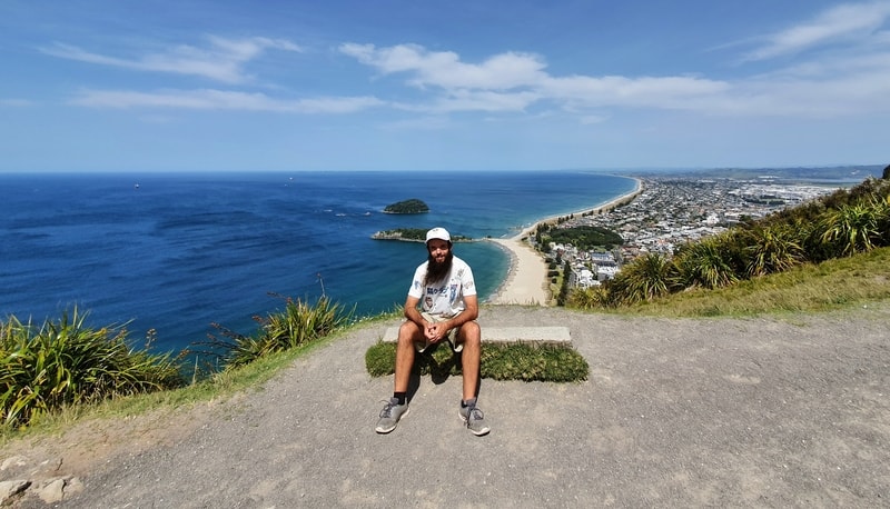
Proof I’ve been to the Mount Maunganui summit
This post will be about walking to the summit via the loop I feel is the best route for your first ascent.
In short, go up the 4WD track and go down the Waikorire track to Mount Maunganui Beach.
TABLE OF CONTENTS
1. Details About The Mount Maunganui Walk
2. Mount Maunganui Walk Map
3. How To Get To Start Of The Mount Walking Track
4. Experiencing Mount Maunganui
1. DETAILS ABOUT THE MOUNT MAUNGANUI WALK
I can’t think of any reason not to deduct any points for this hike! It’s a 5/5 for me.
- It’s easy to access
- Has great views
- Well maintained
- Various routes
- You get to see sheep
- While the ascent doesn’t have much shade there are resting points
Unique Experience: You can walk up Mount Maunganui with former Olympian, Hugh Hutchinson, by booking this Airbnb experience.
When1: Most recently in October 2020
Difficulty2: Easy-medium.
Walk Distance3: Maps.me has the loop at 3.3km but my Strava data has the route you’ll read about below is 4.5km long.
Note: But I think there was an error with the GPS at the summit so I think 3.7km is more accurate.
Elevation Gain 4: Strava calculated the route as having 222 metres of elevation gain, pretty much all of it on the way up to the summit.
How high is Mount Maunganui? The Mount Maunganui summit is ~227 metres above sea level.
How long does it take to walk up Mount Maunganui? As a reasonably fast walk it took me 59 minutes to get up and down. According to the signs, it’ll take you 1 hour and 5 minutes to reach the summit and 1 hour 5 minutes to descent so it’ll take most people 1-2 hours.
2. A MOUNT MAUNGANUI WALK MAP
There are directions available on both Maps.me AND Google Maps. You can see both options below, with both stating different numbers. I always use Maps.me when hiking thanks to being able to use the maps offline.
The starting point for the trip report below is on the corner or Pilot Quay, Adams Ave, and The Mall here.
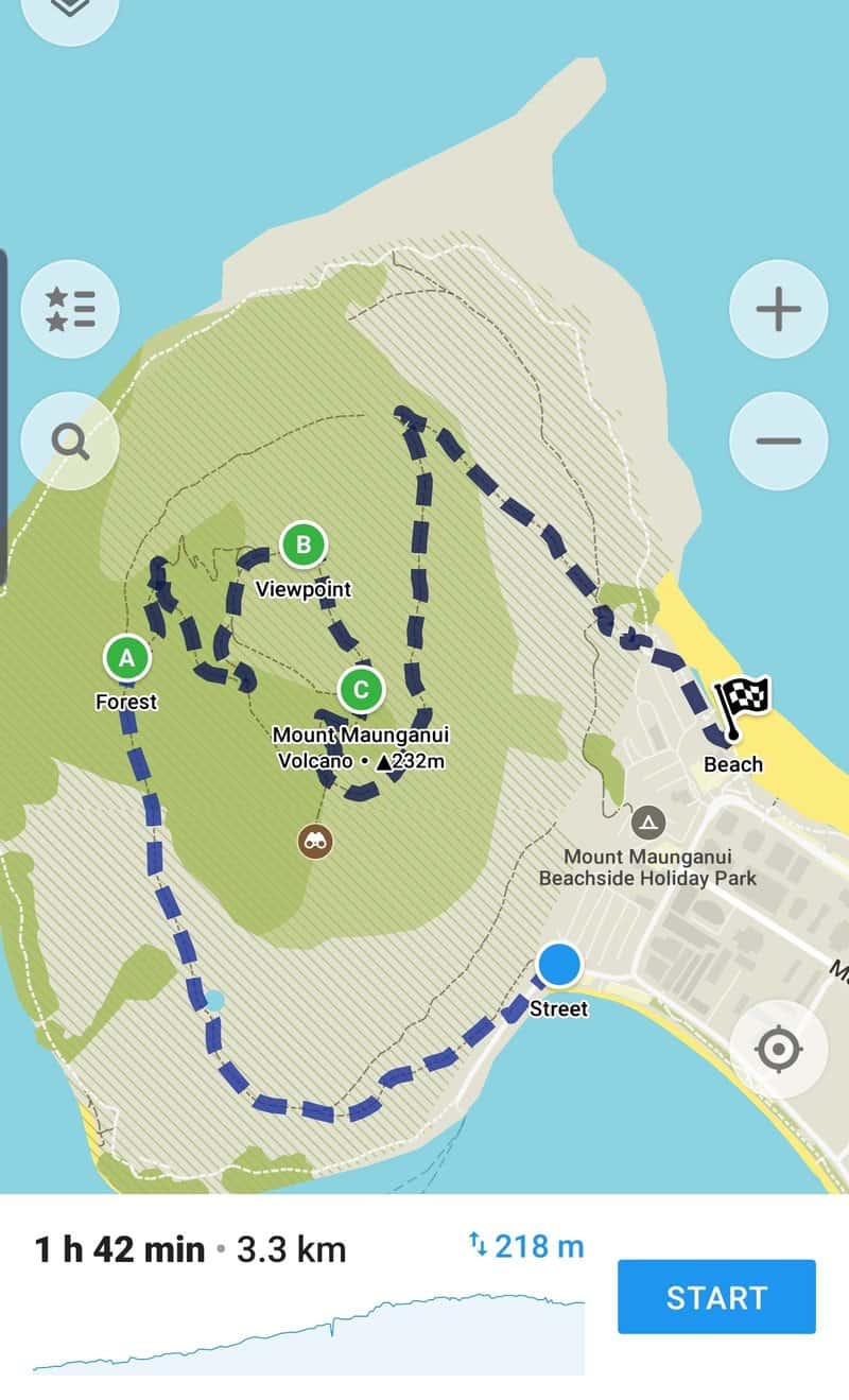
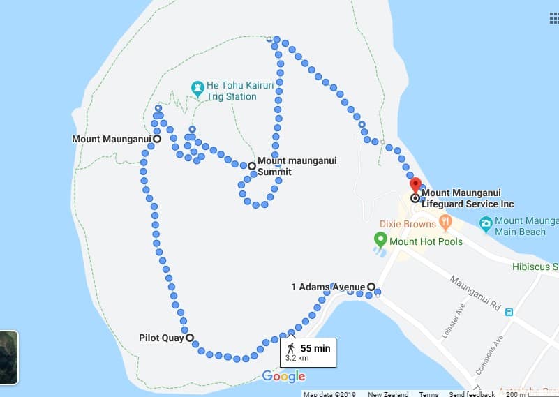
You can view this map via Google Maps clicking this link.
3. HOW TO GET TO THE START OF MT MAUNGANUI WALKING TRACK
Walking: If you’re staying in Mount Maunganui, you can walk from pretty much everywhere to the start of the Mount Maunganui hike. The closest accommodation spot is Mount Maunganui Beachside Holiday Park at the base of the mountain.
Public Transport: This will be most applicable for those who are staying in Tauranga and don’t want to drive (in the middle of summer the traffic is a nightmare).
You can catch the bus by the library in Tauranga (platform A), with two bus options that’ll take you within a minute walk from the starting point.
The best bus to catch is the CL bus to the Adams Ave – Hot Pools stop. The HL bus also goes there too but takes a longer route. Bus tickets cost $3.40 for adults and $2 for kids which are valid for one hour so you’ll need to buy a new ticket to get back (bring cash).
Driving: There are parking spaces nearby, but the biggest issue will be finding a park. Plus, unless you’re there on a Sunday there’s a good chance you’ll need to pay for parking. By going early to do the Mt Maunganui summit walk, you can get a good car park, and see an awesome sunrise.
4. MY MOUNT MAUNGANUI SUMMIT EXPERIENCE
The view from the summit. Ching ching!
Despite the signs I’ve have found it a little bit confusing in the past for people to figure out the best route to the summit, so my mission was to map the best route based on my experience.
Luckily, weather-wise, I picked a good day to do this.
Rising just over 200 metres above sea level, the Mount (Mauao) sticks out like a sore thumb with no other hills for miles.
Note: If you’re looking at the summit from the township, this route takes you in a clockwise direction up the summit.
Starting from Pilot Quay (intersects with Adams Ave and The Mall), you’ll follow the road a little bit before we start the ascent which comes at the summit from the northern side.
There are various tracks on the mountain, so the key is to follow the signs saying Mount Maunganui Summit via 4WD track. This is the best route (in my opinion)
Now, if you’re like me that is confusing as you’d expect 4WD’s to be hooning up the hill. That’s not the case! It’s a walking track only.
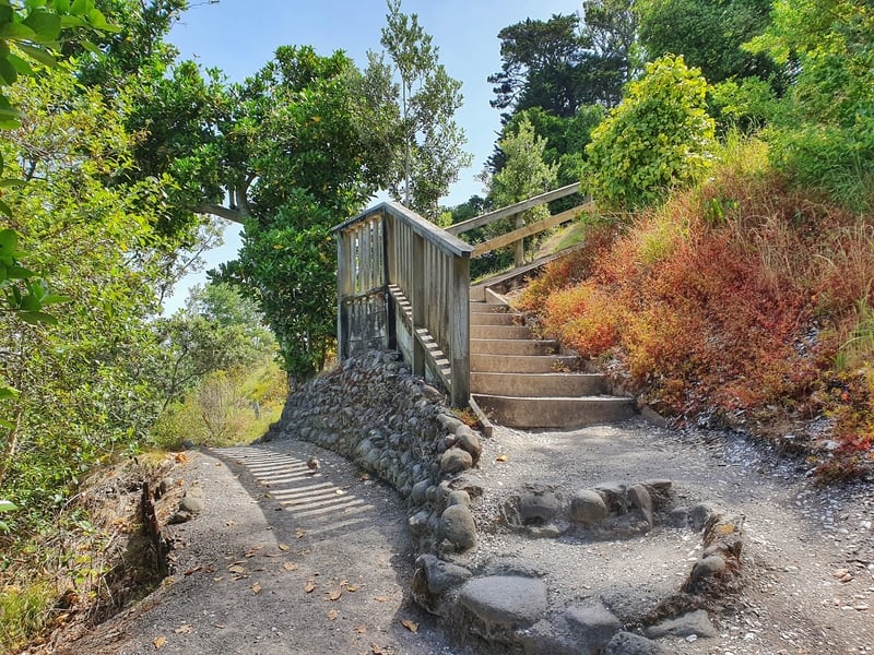
You want to walk up these stairs and turn left.
This is looking back after a few hundred metres of the ascent (spot the sheep)
Anyway, you’ll see a wooden sign close to this set of stairs which you want to go up and once at the top, turn left and pass through the wooden gate. That’s all the navigation needed for a while as we follow the path around the back (north side) of the “mountain”.
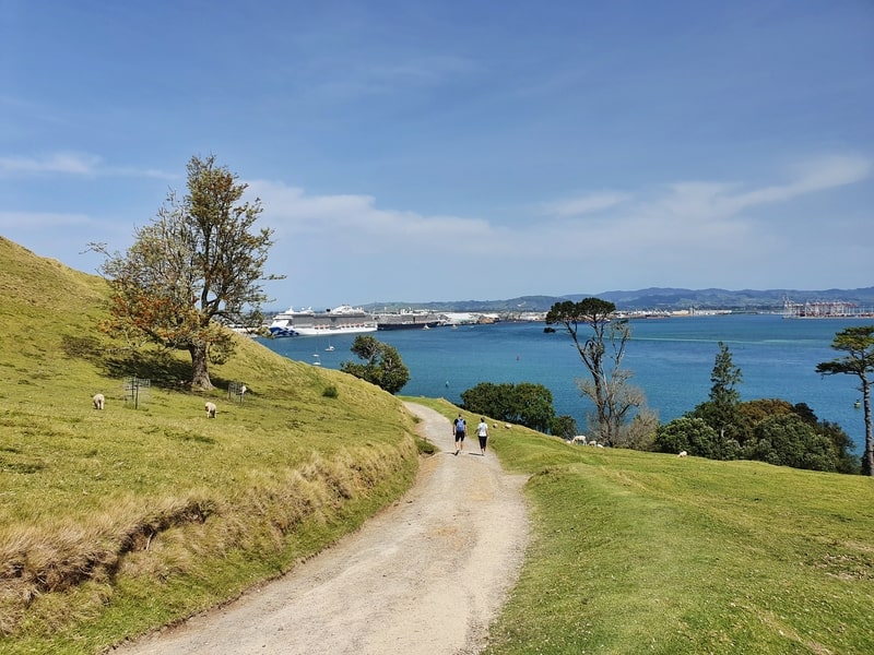
You’ll likely see some sheep (and lambs in the spring) wandering around the track but they’ll run away once you get close enough. So yeap, like the Auckland Coast to Coast this walk will give you a closeup sheep experience.
I loved this photo 🙂
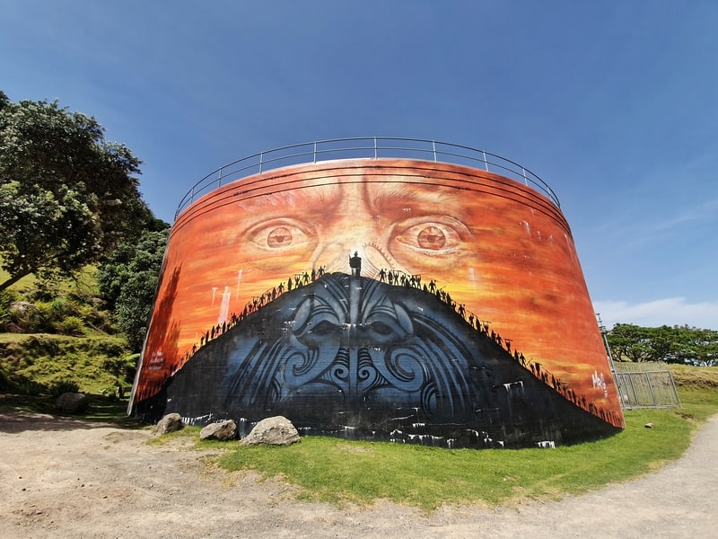
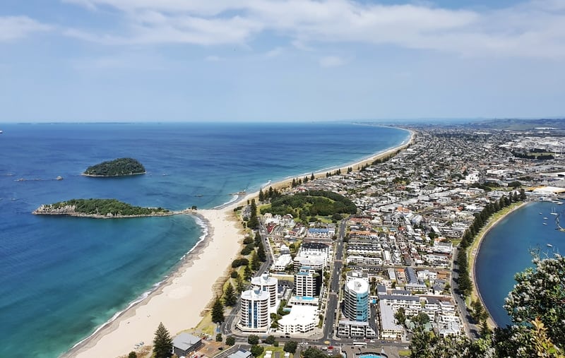
The incline increases as the views of Matakana island open up. Take a minute to admire the art piece on the water tank, it’s epic (see above)!
Once you pass through the second gate, the real grind begins! At least the 4WD track isn’t too ruthless and thanks to the convenient benches placed along the way, there’s time for a break if you need one. The incline will test everyone differently, so stay within your capabilities.
When you see any signs, just continue to follow the direction saying ‘Mount Maunganui Summit via the 4WD track’.
One thing I noticed this time around is just how exposed the track is to the sun on the way up. There’s a brief respite after the second gate, but that’s about it.
This is a viewpoint on the final stretch to the summit
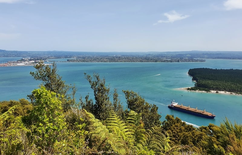
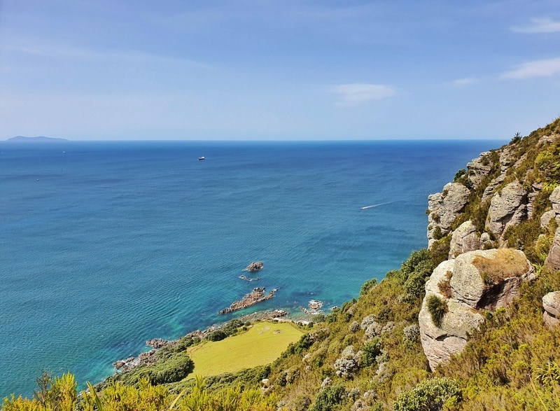
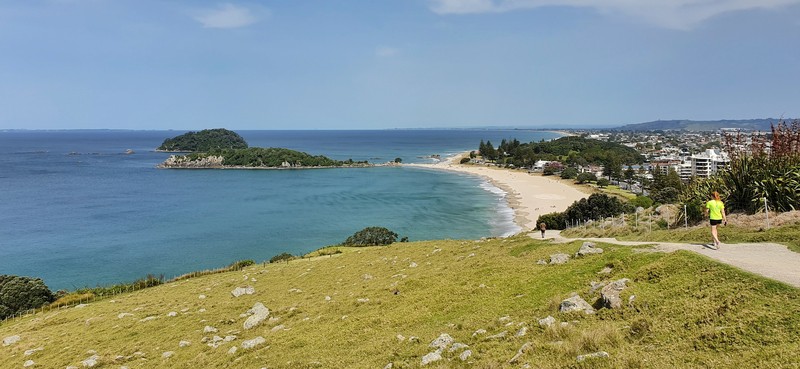
When you get into the final stretch of the Mount Maunganui summit walk, you’ll start to get the epic views again towards Matakana Island and then eventually down towards Mount Maunganui Beach and further south.
There are a few rocky outcrops where people like to sit and relax on the left-hand side of the track, they make for good photos too. Obviously don’t be silly as there are some steep drops if you’re clumsy.
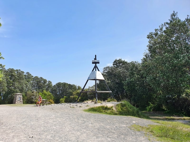
The trig at the summit
Once you’re at the summit find some shade and chill out for a couple of minutes and snap your classic Mount photos. It can be tricky to find the best spots for the photos, but you’ll figure it out and get all that you need.
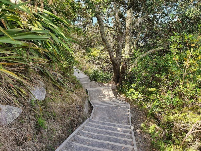
Some of the stairs on the descent.
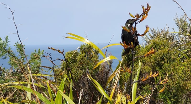
The tui is my favourite bird. I spotted this one on my last summit.
When you reach this point you’re close to the end. Just got to get to that beach!
Now that it’s time for the descent.
Follow the signs for Mount Maunganui Main Beach via Waikorire Track. Coming down the track has a lot more shaded areas, and there are also some stairs (pretty much all of them going down).
It’s not crazy crazy steep at any point, so you’ll cruise on down the side of the mountain until you exit out towards the base which gives a different perspective on the beach and beyond. From here you’ll coast along until you reach the beach.
If you’re thirsty you won’t have any issues finding the beverage of your choice nearby.
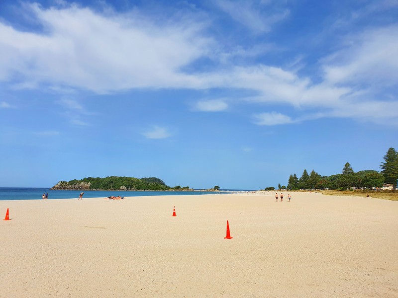
Mount Maunganui Main Beach! It’s time to relax yo.
This is another one of the hikes in New Zealand that offers plenty of bang for your buck. With just over 200 metres of elevation, this should be doable for everyone.
What are your thoughts? Do you want to go or have you been already on the Mount Maunganui summit walk? Leave a comment below with your thoughts 🙂
p.s. If you aren’t a fan of walking up hills, you can walk the Mount Maunganui base track. It’s obviously not going to have the awesome views, but it’s a nice walk that’ll take no more than an hour.
What to read next:
- 230+ Things to do in New Zealand
- Walking to the North Islands highest waterfall
- My Hobbiton Review
- The nearby Papamoa Hills walk

Hey, it’s Jub here. I’m the guy behind Chur New Zealand, helping you have the best time hiking, trekking, walking…whatever you want to call it…in NZ. I’m based in Queenstown and am always out and about exploring trails, old & new. If you have any questions, reach out.
We love working and being in “The Mount” as we call it. Great article!
I can imagine it’s a lifestyle many will envy 🙂 Thanks for commenting Jude!